
How to read an old map before you tell its story
A map is a dated object with a purpose and a vocabulary. Read those first, then decide what the lines and blank spaces can support.
An old map can answer a question such as “what did this maker place here?” It cannot, by itself, prove that every border was accepted, every road existed as drawn, or every blank area was unknown. A good audio guide starts by reading the map as an object with a date, a purpose, a scale, and a set of symbols.
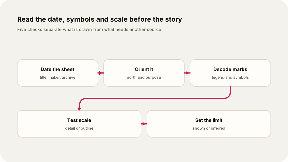
Read the frame before the place
Start with the map’s title, orientation, source, legend, grid and scale. These details help you identify what the map describes and how it presents the place. A map made to show land ownership has a different purpose from a chart made for navigation or a map drawn to support a territorial claim.
Start with the title and date. A date printed on the sheet may be the publication date, while a catalogue may record a different date for an edition, a manuscript addition, or the item’s history. Then find orientation. North may be at the top, but a compass rose or an unusual projection can change how the page reads. Look for the scale bar or ratio before comparing distances. The Library of Congress map guide describes how small-scale maps show larger geographic areas in less detail.
Let the legend do the talking
A legend is a translation key. It may tell you that a red line is a road, a green line a waterway, or a particular mark a settlement. Do not treat every line as a fact of the landscape until you know what the map’s symbols mean. Relief may be drawn through shading. A blank area may mean that the map does not show that feature, not that no feature existed.
Look at the choices on the sheet: its title, place names, boundaries and decorative panels. Ask what each one shows before inferring the maker’s purpose. The audio should separate what is drawn from what you infer. “The map marks a route in red” is an observation. “The route was the main road used by everyone” needs another source.
A concrete archived map
The British Library catalogue record for IOR/X/3097 describes a map published in London in 1797 by William Faden and engraved by William Palmer. The record gives an approximate scale of 1:7,900,000 and an orientation of north. It also lists visible conventions: relief is shown by shading, land routes are red, sea routes and waterways are green, and place names appear in Latin and English. Legends and historical notes cover the face of the map.
That record gives an audio writer several grounded sentences. You can say that the sheet is dated 1797, covers a large region at a small scale, and uses stated colour meanings. You can ask what the Latin and English names suggest about the intended readers. You cannot use the sheet alone to decide whether every route was current, how travellers experienced it, or whether the historical notes were accurate. Those questions need travel accounts, administrative records, or other maps.
The British Library’s wider India Office map collection is a reminder to check the archive’s description. Individual records can add scale, language, physical dimensions, and digitised content. The catalogue record is evidence about the object and its description, not a substitute for every claim about the place.
A five-step listening script
- Identify the sheet: title, maker, date, archive, and catalogue reference.
- Orient the listener: north, region, projection if supplied, and the map’s stated purpose.
- Decode the legend: read only symbols the record or sheet explains.
- Test the scale: say whether the map shows a city in detail or a whole region in outline.
- Mark the boundary: label an observation, an interpretation, and a question that needs another source.
Example show request: “Read the British Library’s 1797 IOR/X/3097 map as a short history guide. Explain the date, north orientation, 1:7,900,000 scale, red land routes, green waterways, and Latin and English place names. Separate what the map shows from what it cannot prove.”
Ask Lissin to make the episode a close reading, a narrated walk through the legend, or a comparison with a second map. Give it the archive link and tell the show where to stop inferring. The museum object audio guide uses the same discipline for physical objects, while the oral history audio guide shows how to keep a source’s voice and a narrator’s explanation distinct.
Sources
- Library of Congress, Maps from the World Digital Library: orientation and scale, with a collection of maps for classroom reading.
- British Library, IOR/X/3097 catalogue record: 1797 date, maker, scale, orientation, relief, route colours, and bilingual place names.
- British Library, India Office reference collection of maps: collection scope and archival context for map records.